Cat Rocks: Family-Friendly Hike in Pawling
/Your kids probably aren’t quite ready to hike 2,150 miles from Georgia to Maine (although they might be), but this 3-mile round-trip hike to the scenic overlook known as Cat Rocks, just below the summit of West Mountain in Pawling, is a good introduction to the AT.
Expect some company: Cat Rocks can be a crowded spot. It’s the halfway point in a popular 7.5 mile day hike that goes from the Appalachian Trail Metro-North stop on Route 22 all the way to Route 55 with a stop over at Nuclear Lake. (Guess how Nuclear Lake got its name? You’re right!) But it’s always fun to meet people who are in the middle of through-hiking, or at least tackling large sections, of the AT, and this hike even gives you a chance to check out an AT shelter.
We especially enjoy this hike in early spring when the skunk cabbage has emerged, seasonal snow-melt streams are rushing, and tasty fiddleheads and ramps can be found if you keep an eye out. Plus, since the trees haven’t filled out yet, when you get to Cat Rocks you might be able to see your car parked at the bottom.
 |
| Cat Rocks lookout in spring |
- Begin by parking here on West Dover Road/Route 20, by the massive, 300-year-old oak tree known as the Dover Oak. More than one guide to the AT claims that the Dover Oak is the largest blazed tree on the entire 2,150-mile length of the trail. Speaking of blazes: You’ll be following the white blazes for pretty much the entire hike.
Parking area Appalachian Trail - Cross the road and take the stairs down into the skunk cabbage marsh. There are some boardwalks to take you over the muddiest parts, but you should still be wearing something waterproof on your feet.
- After the marsh is the hike’s only tricky part: a rocky outcropping that you’ll have to scramble up. The ascent is gradual enough that it’s not too difficult, but if it has rained recently, the rocks can be quite slippery. Take your time, and keep a hand on the wee ones as you guide them up the slopes.
Rock scramble - It’s smooth sailing from here. You’ll soon reach a wooden bridge that traverses a seasonal stream. Also, look for a tree on the left side of the trail right here that Cooper swore looked like a giant dinosaur foot.
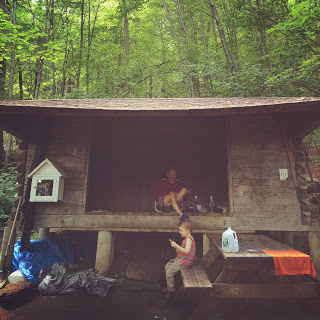
Exploring the stream - Shortly after that is the junction with the 0.1 mile-long blue trail, which branches off to the left. It’s worth your time to check it out. Not only is there a beautiful rushing stream with cascades and frog ponds, but it also leads to the Telephone Pioneers Shelter - so named because it was built by the White Plains chapter of the Telephone Pioneers back in the 1980s. The Telephone Pioneers is what they used to call the volunteer service programs run by the various telephone companies. Today they’re known as the Telecom Pioneers because landlines? LOLOLOL. What’s also notable about this particular shelter is that a mini-library is attached to it, run by the Pawling Free Library. Hikers are encouraged to take, or leave, a book. The last time we visited the shelter we ran into a section hiker named Gas (all AT hikers give themselves a trail nickname) who had so far hiked the AT all the way up from Georgia, and he told us that was the first library he’d ever seen attached to a shelter.
Appalachian Trail: Telephone Pioneers shelter - Backtrack to the junction, and continue along the white-blazed trail for the final push to the top. Cat Rocks is actually just off the trail itself. You’ll see an unmarked trail branching off to the right around here, and the view will be partly visible. Head right for about 100 feet and you’re there, facing east. Plop yourself down and have a snack! If you want to reach the true summit of West Mountain, head back to the trail and push ahead another 0.1 mile for a north-facing view.
Almost to the lookout - From Cat Rocks, backtrack down to the trailhead. Again, use some caution when you reach the rocky, sloping outcrop near the trailhead. Honestly, we’ve found that it’s easier to just slide down most of it on your bottom. We call it “booty-scootin’” which Coop find hilarious. Then he won’t stop saying “BOOTY SCOOTIN’! BOOTY SCOOTIN’!” for, like, days. You know what? Maybe it’s better to walk down.
Cat Rocks lookout in summer


Where to park: The parking shoulder is here on West Dover Road/Route 20, on the side with the giant oak tree (trust me, you can’t miss it). If you’re coming from the south: If you pass Valley View Farms Road on the right, you’ve gone too far by about a mile. If you’re coming from the north: Once you pass Valley View Farms Road on the left, start paying attention, because you’ll hit the trailhead in about a mile.
What to pack for the kids:
- Snacks and water
- First aid kit
- Insect repellent (The bugs can be bad on the trail’s swampier sections in the summer.)
- Binoculars
- Waterproof shoes with good grips
- Maybe even a book to leave at the shelter library
Brian PJ Cronin, editor of Hudson Valley Parent magazine and local writer extraordinaire, shares his writing talents in focusing on family-friendly hikes for our Hiking Series. The beautiful photography is by Kristen Cronin, local do-gooder and co-founder of For Goodness Bake.